Software
Fully Featured Processing and Viewing Applications

Mandli offers a variety of software applications that can be customized to meet the needs of any project. Roadview Workstation is Mandli’s next generation data viewing and asset inventory software, and allows users to access all collected data in an easy-to-use, synchronized viewing environment. Route information, imaging, GPS, pavement, and LiDAR data can all be accessed through a variety of search and filter tools. Roadview Explorer is an interactive environment that is used for working with roadway images and data using a web browser, and allows users to view images, data, and information through URL access. For basic image viewing, Mandli offers Roadview Player, which displays single or multiple camera right-of-way images in succession along with corresponding road index data.
- Roadview Workstation offers fully featured imaging, GNSS, LiDAR, and pavement interaction tools
- Roadview Explorer allows for web access to roadway images and data
- Roadview Player is a quick and efficient image and road index data viewer


Workstation features basic navigational commands, such as playing routes forward and in reverse, U-turn functionality, and jump to location. When applicable, the software is able to display a list of each cycle or year that the data was collected for viewing and comparison. The user is able to jump to any location in any collected route through a variety of methods, including search and filter tools. For example, the user is able to search for the highest area of distress within all collected routes using the built-in filter functionality. Selecting that area of distress not only brings up the pavement image and distress information, but the right-of-way images and positional data as well. The map function allows users to import custom shape files and overlay them on an active map of the collected routes. The user is able to export a variety of information by printing, exporting to CSV files, and creating graphs from a multitude of datasets to highlight areas of interest. These outputs can be customized to fit a variety of reporting formats.
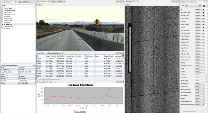
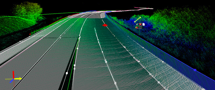
The ability to view LiDAR data that is synchronized with the other datasets is one of the strongest features of Workstation. The LiDAR data is presented in a fully interactive 3D environment that allows the user to view and interact with roadway assets. Included with the delivery is an asset table that has been customized to the requirements of the client. The user is able to view this table, filter the information, and jump to any single asset of interest. For example, the user can bring up all of the signs on a given route within the asset table. Displayed within this list are attributes such as MUTCD code, mount type, linear reference, geospatial reference, height, width, distance from edge of pavement, and height above roadway. The user is able to interact with all of this data, search for individual signs or groups of signs, jump to their exact location on a route, and be presented with corresponding imaging, positional, and pavement data.
As a fully featured Java application, Explorer seamlessly integrates high-resolution right-of-way and pavement images, GPS data, and centerline maps into an intuitive point-and-click interface. All images and data are accessed from a centralized server via intra/internet access. Explorer only allows data to be read, not edited, and no installation is required on individual computers. Secure login information can be created for the software to provide different levels of access to the data.
Roadview Player is a versatile interactive viewing environment for right-of-way images and data. The software plays single or multiple camera right-of-way images in succession along with corresponding road index data. The player controls allow the user to play through in forward and reverse, step forward and backward, move to the beginning or the end of a route, magnify images, change playback speed, and search the images by frame.